Gulf Coast Aquifer
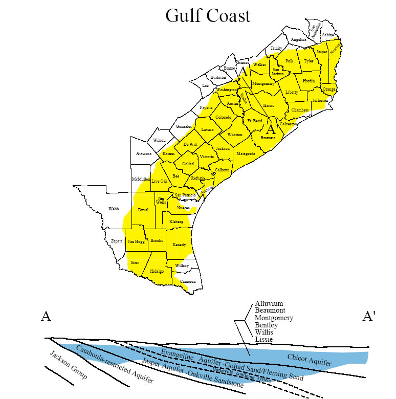
The Gulf Coast aquifer forms a wide belt along the Gulf of Mexico from Florida to Mexico. In Texas, the aquifer provides water to all or parts of 54 counties and extends from the Rio Grande northeastward to the Louisiana-Texas border. Municipal and irrigation uses account for 90 percent of the total pumpage from the aquifer. The Greater Houston metropolitan area is the largest municipal user, where well yields average about 1,600 gal/min.
The aquifer consists of complex interbedded clays, silts, sands, and gravels of Cenozoic age, which are hydrologically connected to form a large, leaky artesian aquifer system. This system comprises four major components consisting of the following generally recognized water-producing formations. The deepest is the Catahoula, which contains ground water near the outcrop in relatively restricted sand layers. Above the Catahoula is the Jasper aquifer, primarily contained within the Oakville Sandstone. The Burkeville confining layer separates the Jasper from the overlying Evangeline aquifer, which is contained within the Fleming and Goliad sands. The Chicot aquifer, or upper component of the Gulf Coast aquifer system, consists of the Lissie, Willis, Bentley, Montgomery, and Beaumont formations, and overlying alluvial deposits. Not all formations are present throughout the system, and nomenclature often differs from one end of the system to the other. Maximum total sand thickness ranges from 700 feet in the south to 1,300 feet in the northern extent.